
Department of Geography and Urban Planning, University of Isfahan, Iran
Journal of Urban and Regional Analysis, vol. IV 1, 2012, p. 77-89
Introduction
During the past century, the world’s population has been rapidly congregating in urban areas. The urban population in the world was estimated at 2.4 billion in 1995 and a doubling is expected at about the year 2025 (Yu and Ng 2007). According to the United Nations estimates, the population living in urban areas exceeded 50% of the world total in 2006 and will approach 60% in 2020. Most if not virtually, all this growth is taking place in developing countries. While the explosive urban growth in the Global South is a well known phenomenon, the specific trajectories and forms of this growth are still relatively unknown. In most of the world, urban growth appears to have taken the form of disperse or sprawled patterns but case studies are needed to ascertain whether the “American model” of urban sprawl is dominant or, rather, it represents just a version of a much wider process (Zanganeh Shahraki et al. 2011). While the explosive urban growth in the Global South is a well known phenomenon, the specific trajectories and forms of this growth are still relatively unknown. In most parts of the world, urban growth appears to have taken the form of disperse or sprawled patterns, but case studies are needed to ascertain whether the “American model” of urban sprawl (Leichenko and Solecki 2005) is dominant or, rather, it represents just a version of a much wider process.
Urban sprawl is a pattern of land use exhibiting low levels of eight distinct dimensions: density, continuity, concentration, clustering, centrality, vagueness , mixed uses and proximity. Density is the average number of residential units per square mile of developable land in an urban area. Vagueness is the degree to which developable land has been built in close proximity to the already existing urban fabric. Concentration is the degree to which development is located disproportionately in relatively few square miles of the total urban area rather than spread evenly. Clustering is the degree to which development has been tightly bunched to minimize the amount of land in each mile of developable land occupied by residential or non-residential uses. Centrality is the degree to which residential or non-residential development (or both) is located close to the central business (CBD) of an urban area. Not clear is the extent to which an urban area is characterized by a mononuclear (as opposed to a polynuclear) pattern of development. Mixed uses means the degree to which two different land uses commonly exist within the same small area. Finally, proximity is the degree to which different land uses are close to each other across an urban area (Glaster et al. 2001). Because of these characteristics, urban sprawl is said to represent a threat for urban sustainable development since it implies an increase in the consumption of land, water, energy and other resources as well as of pollutants and waste. The environmental impacts of urban sprawl have raised concerns among planners and have stimulated other models of urban expansion such as “smart growth” (Gabriel, Faria, Moglen 2006, Litman 2007, Turner 2007) which attempt to reverse the low values of the eight dimensions stated above.
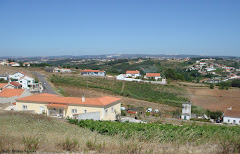
After (1961-1971), in Iran, having an increased cities’ population, because of both high natural growth and large scale immigration of villagers to cities, the growth of urban form and construction did not happen based on needs but on land mongering. This led to an unorganized urban land market, especially within urban limits and the negative distribution of cities’ sprawl and horizontal expansion (Athari 2000). Following the pattern of other large Iranian cities in recent years, Urmia City has had rapid and unorganized growth. This city has witnessed many population and form changes because of the population’s natural growth, immigration, the spread of services, the allocation of official-political identity to this city as a province capital, the land grant by different governmental organizations within this city, the state’s construction plans, state’s socioeconomic and political changes and or ultimately the appropriate natural environment. This city’s population has increased from 67,605 in 1956 to 583,255 in 2006. Also, in accordance with the calculations of consultant engineers, in a twenty- year interval (1986-2006), the urban area has increased from 5939 to 8577 hectares in this city. This in turn has added 95% to the initial urban area during this period (West Azerbaijan’s Organization for Housing and Urban Planning, 2008).
Furthermore, these factors have resulted in the lack of land and housing, the split of urban texture, the disorganization of urban visage, the crowdedness of urban transportation (the congestion of urban traffic, especially in the city center), the conversion of appropriate agricultural lands into residential and industrial spaces, thoughtless urban constructions and the exhaustion of natural capabilities and services, the endangered urban environment which contributed to the city instability. In such conditions, it is important to improve the consequences of thoughtless urban sprawl. However, few solutions have been suggested to mitigate the consequences of this phenomenon, i.e. population growth. Strategies such as smart growth, smart management, green belts and land use planning have been proposed and implemented in other locations as possible solutions for reducing the negative impact of the urban sprawl.
...

Urban sprawl has increasingly become a major issue in the global trend towards urbanization. Faced not only by developed countries but also by developing countries, and by large urban centers and medium and small cities alike, urban sprawl raises social and environmental concerns at the same time that shows a multiplicity of divergent trajectories that somehow defy the dominance of homogeneous characteristics around the world. This study examined the urban sprawl of Urmia, one of the most important historical, cultural, industrial, and commercial cities in north Iran, Urmia city. In recent years, the Urmia City has had the rapid growth of population and urban area, because of so appropriate natural prerequisites (so desirable lands for agriculture and many water resources), of the development of roads and the construction of housings beside them, immigration (which led to the approach of lands around the city to the city itself (these parts joined to the city boundary), of cooperatives for town building, development and construction of disorganized settlements and urban margin living), and of the ownership issues.
As in many cities in the developing countries, sprawl in Urmia appears as an unplanned and disordered pattern which has emerged after the location of existing highways, villages and towns and has been created by the realities of differential land rents, industrial location, and communication networks. Also, such rapid and unplanned growth has created important problems such as lack of enough services and facilities for the residents, insecurity, increase of commuting length, and of energy consumption, and local climate change, among other matters. Finally, sprawl leaves behind numerous interstices that may be used for other functions such as agricultural land or for infilling policies, although the former appears more important than the latter. By applying quantities models, some conclusions were drawn: 1) findings resulted from Holderness Model indicate that only 59% of urban growth has been in the result of urban growth and 41% of urban growth is related to urban sprawl and horizontal growth which contribute to the gross density of population and the increase in urban gross land per capita; 2) the value of Shannon’s Entropy is 1.3738 for 1989 whereas the maximum value is Ln(4) = 1.3862. The closeness of the entropy value to the maximum value shows the sprawl growth of urban physical development. The Shannon’s Entropy is 1.3231 for 2007, suggesting that during twenty years, physical growth has been in a sprawl and incompact manner.
According to the findings of this study, uncontrolled urban sprawl in Urmia has caused many changes in the land use of the peripheral areas. The causes of having such widespread urban sprawl should be studied in order to develop strategies for controlling the city’s growth. Some of the strategies and policies that can be used for controlling the urban sprawl are: creating a re- gional balance to reduce migration from rural areas to urban areas or the renewal and improve- ment of the central-historical fabric and of the inner city of Urmia. This would cause the continu- ous settlement of population in these areas for living and would prevent migration from center to the suburbs. Also, the policy of infilling development can be used to provide for the future growth of the population, and for implementing strategies addressed to manage the construc- tion in the undeveloped peripheries.
The necessity of its change and the enjoyment of strategies for more compactness of the city should be considered with respect to the direction of urban development towards more sustainability and regarding that this study’s findings on urban sprawl growth have had many consequences in different economic, social and biological divisions including the exhaustion of agricultural lands around the city, the devastation and contamination of water and soil resources, the increase in the cost of delivering civic services, the increase in the time and length of inner city trips. As a result, the consumption of fossil fuels like petroleum increased, social segregation appeared, there is a lack of care about land use or irregular use of this im- portant resource.
Link para o artigo completo:
http://www.jurareview.ro/2012_4_1/p_77_89_2012.pdf


Sem comentários:
Enviar um comentário